Drought and water update - February 2025
Drought monitor
Increased precipitation levels have decreased drought conditions in both scale and severity across Idaho and Montana, though significant portions remain in severe condition. Oregon and Washington are nearly out of drought outside of coastal regions. Severe and extreme conditions have expanded south of Sacramento, California and into much of Arizona. For the latest on weather, please see AgWest’s Weekly Weather Updates with Eric Snodgrass.
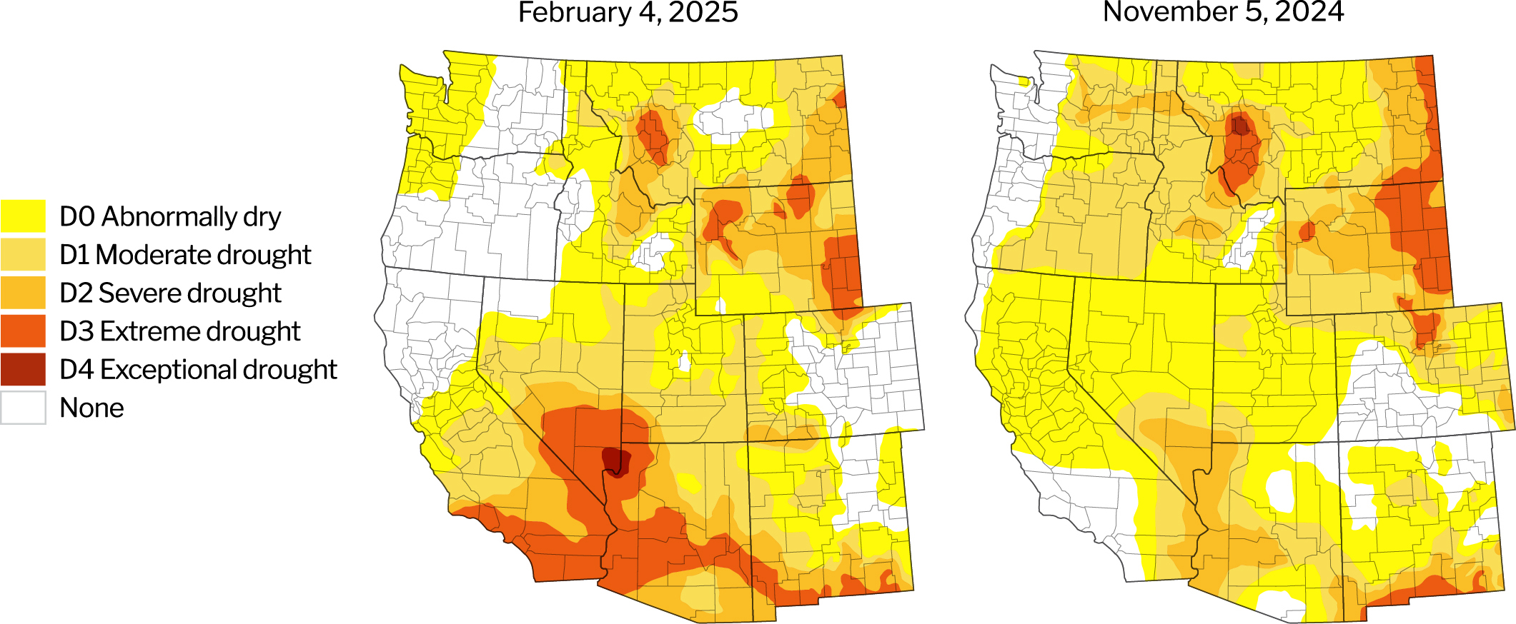
Source: U.S. Drought Monitor, University of Nebraska.
Description – The U.S. Drought Monitor provides a comprehensive look at drought conditions across the U.S., categorizing areas by intensity (no drought to exceptional drought). This tool helps agriculture producers understand water availability and make informed decisions about crop management.
Year-to-date precipitation
Year-to-date precipitation levels (Oct. 1 – Feb. 5, 2025) are mixed across the West. While those in Oregon, Southern Idaho and portions of Montana are at/above their historical averages, much of the region remains below.
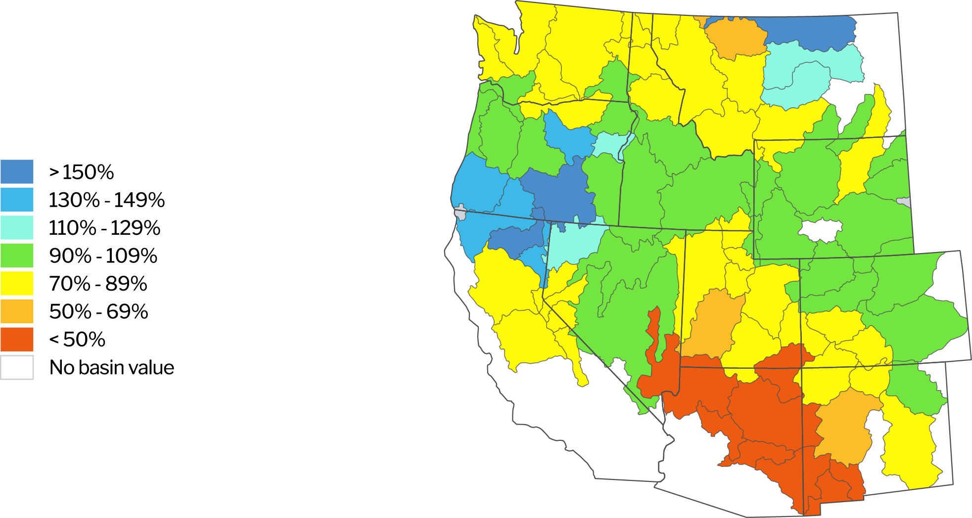
Source: Natural Resources Conservation Service. NWCC Interactive Map. Data as of Feb. 6, 2025.
Description – The NWCC Year-to-date Precipitation Map provides a detailed overview of precipitation levels across the U.S., comparing current data to a historical average. Similar to the Drought Monitor, this tool helps agriculture producers understand water availability and make informed decisions about crop management.
Reservoirs with low water levels
Reservoir levels strengthened across much of the West, with the number of those notably under their historical average decreasing from 17 to 9. Significant improvements were seen in the Rogue River Basin and Southeastern Oregon. Except for the Cle Elum reservoir, the Yakima River and Deschutes River Basins experienced modest improvements.
Reservoirs with water levels below 80% of their historical average
| Location/Region | Reservoir | Percent of average level | Percent of previous year |
|---|---|---|---|
| Colorado River Basin | Lake Powell | 57% | 101% |
| Lake Mead | 54% | 94% | |
| Deschutes River Basin, OR | Crescent Lake | 32% | 127% |
| Rogue River Basin, OR | Four Mile Lake | 64% | 108% |
| Yakima River Basin, WA | Bumping | 37% | 26% |
| Cle Elum | 26% | 47% | |
| Kachess | 42% | 99% | |
| Keechelus | 37% | 61% | |
| Rimrock | 37% | 44% |
Data as of February 6, 2025.
Source: Bureau of Reclamation: Reservoir Storage. California Department of Water Resources. Arizona Department of Water Resources.
Description – Reservoirs are an important source of water for agriculture producers throughout the West. This section identifies those with water levels at 80% or below of their historical average for the given period. Reservoirs at or above 80% of their historical average water levels are not included in this list.
Updates impacting water access
Arizona
The Colorado River Basin is just shy of its mid-January median, meaning Arizona could experience water cuts through 2026. Runoff is projected to fall to 82% of average in 2025, which may lead to a continued Tier 1 Shortage declaration in 2026. Central Arizona Project (CAP) agricultural irrigation districts are likely to continue facing increased costs and reduced deliveries.
Arizona Department of Water Resources (DWR) issued an order designating the Willcox Groundwater Basin as an Active Management Area (AMA). Irrigators who have used groundwater over the five years proceeding October 2024 will continue to have access, while others will not. This action also sets guidelines on grandfathered rights and measurement/reporting requirements.
The Fifth Management Plans, a set of plans designed to align groundwater usage with recharge rates throughout Arizona’s AMAs, will begin implementation in 2025. Key changes include a 5% reduction in water duties for the top 25% of high-water-use farms and the implementation of a new Best Management Practices framework to incentivize efficient water use.
The Colorado River Compact, an agreement that manages water allocations to lower basin states (Arizona, California and Nevada) and upper basin states (Colorado, New Mexico, Utah and Wyoming), expires in 2026. Contentious negotiations among the states are ongoing. Lower basin states want the upper basin to take a greater share of future cuts, and Arizona wants other states to help ensure that CAP water continues flowing.
California
Drought is once again becoming a concern for the current water year in California. In particular, the southern half of the state has been very dry, which contributed to devastating wildfires in the Los Angeles area. As of Feb. 6, statewide snowpack is at 41% of the April 1 average, the typical yearly high point.
President Trump issued a wide-sweeping executive order that may impact water access in California. While the resulting actions are not yet clear, and this order may be challenged in court, it authorizes federal entities to identify and change existing activities, regulations and policies that unduly restrict water deliveries for various uses, including wildfire fighting and hydropower.
California DWR increased allocations to 20% for the State Water Project from the 15% announced in January 2024. Storms in November and December 2024 helped to saturate the ground and modestly support reservoir levels, which are currently near their historical averages.
Farmers with land in the Tule and Tulare Lake subbasins under the jurisdiction of the Tri-County Water Authority GSA have until March 1 to register any well with annual pumping of more than two acre-feet or face a $150 per month penalty.
The San Luis-Delta Mendota Water Authority will receive $204 million in federal funding to help repair the Delta-Mendota Canal, which should restore the canal to its maximum delivery capacity and provide relief to local agricultural contractors and wildlife refuges.
The Kern Subbasin’s fourth Groundwater Sustainability Plan was deemed inadequate by the State Water Resources Control Board (SWRCB) in a preliminary review. Probationary Status would empower SWRCB to enact well registration and reporting requirements, limit water pumping, and authorize an interim plan to supersede Kern Subbasin’s sustainability plan until it is deemed satisfactory by the SWRCB.
The Westside District Water Authority imposed a ban on all groundwater pumping within 2.5 miles of a 30-mile segment of the California Aqueduct. The California Aqueduct, which conveys water for the State Water Project, has suffered damage due to land sinking, likely caused by excessive groundwater pumping in the area.
The Metropolitan Water District of Southern California agreed to provide $141.6 million to fund planning and pre-construction projects for the Delta Conveyance Project, which intends to modernize water infrastructure in the Central Valley. The project faces stiff opposition from environmental advocacy groups due to potential impacts on endangered/threatened fish species.
The U.S Bureau of Reclamation (USBR) and water agencies of the Bay Area and the San Joaquin Valley have agreed to begin a nearly $1 billion project to increase the capacity of San Luis Reservoir. The reservoir’s dam will be raised by about 10 feet, increasing water storage capacity by about 130,000 acre-feet. Federal funding will cover approximately 30% of the project’s costs, while local agencies will contribute the balance.
The Sacramento Area Sewer District began implementing a new project known as “Harvest Water,” which would allow the distribution of recycled sewer water to local agricultural districts in the Sacramento Valley. This program will reduce groundwater demand by supplying up to 50,000 acre-feet per year of drought-resistant water irrigating more than 16,000 acres of agricultural lands.
User fees are under consideration for the Paso Robles Groundwater Basin to help pay for sustainability projects. Agriculture producers could pay anywhere from $64 to $246 per acre-foot of water depending on the chosen rate structure. It remains unclear when this would go into effect.
Idaho
Snowpack conditions of the Upper Snake River are generally adequate, but more snowpack and favorable runoff conditions may be required to ensure full allocations for irrigators.
Idaho DWR finalized the 2024 Stipulated Mitigation Plan, an agreement between the surface water users (collectively called the Surface Water Coalition) and groundwater districts in eastern and southern Idaho. The plan is designed to protect water resources for surface water users while meeting the needs of groundwater users. The primary differences in this agreement to its predecessor include:
- Water allocations expanded from one-year to four-year terms. Groundwater users will be responsible for managing their supply over the four-year period.
- Groundwater districts taking part in this agreement are required to collectively conserve 205,000 acre-feet of water annually.
Oregon
Oregon has experienced good snowpack this winter and is nearly fully out of drought.
Governor Kotek signaled water quality and availability are among her top priorities this legislative session and is likely to put particular attention on overdrawn water basins and groundwater contamination in Eastern Oregon and other critical groundwater areas. This may result in changes to Oregon’s Groundwater Quality Protection Act and greater authority for the state to manage water allocations and regulations.
A federal appeals court ruled that the USBR can restrict the Klamath Drainage District’s (KDD) withdrawal of water from the Klamath River per a 1946 contract. A federal judge issued an injunction in 2023 stopping KDD from withdrawing water without USBR’s permission.
Researchers from the University of Oregon discovered a massive aquifer located at the crest of the central Oregon Cascades. It is reportedly among the largest of its kind. While uncertainty remains around its full size and recharge rates, the discovery may eventually impact nearby water users.
Montana
Drought conditions have improved in Montana as snowfall picked up in January. Snowpack levels are improving in the mountains and while some areas are still below average, they appear to be catching up. Moisture levels in the plains have improved as well, though much more is needed to return to normal conditions. There is increasing optimism that irrigation water availability will improve for the upcoming growing season.
Washington
While year-to-date precipitation remains below average for much of the state, much of the snow accumulation season is still ahead. Water supply forecasts are generally near normal.
Washington’s Department of Health is considering changing how it exempts small farms from certain testing and quality requirements. While the department argues the current language is outdated, the proposed policies (recertification every five years) could raise costs for producers who house workers onsite at a time when many of them face a very difficult operating environment.
Return to Industry Insights home page
IN THIS SECTION
![]()
.jpg?Status=Master&sfvrsn=68087301_1 "My project-1 (26)")
Economic headlines, data and trends
Monthly economic trends, data and major industry headlines.
Learn more