Drought and water update - May 2025
Drought monitor
Drought conditions were relatively stable over the last quarter. Coastal Washington experienced a slight improvement, while extreme and exceptional drought conditions expanded in portions of the Southwest. Conditions in northern Montana were mixed, with some degradation in the northern region and improvement along the Rockies and eastern border. For the latest on weather, please see AgWest’s AgWest’s Weekly Weather Updates with Eric Snodgrass.
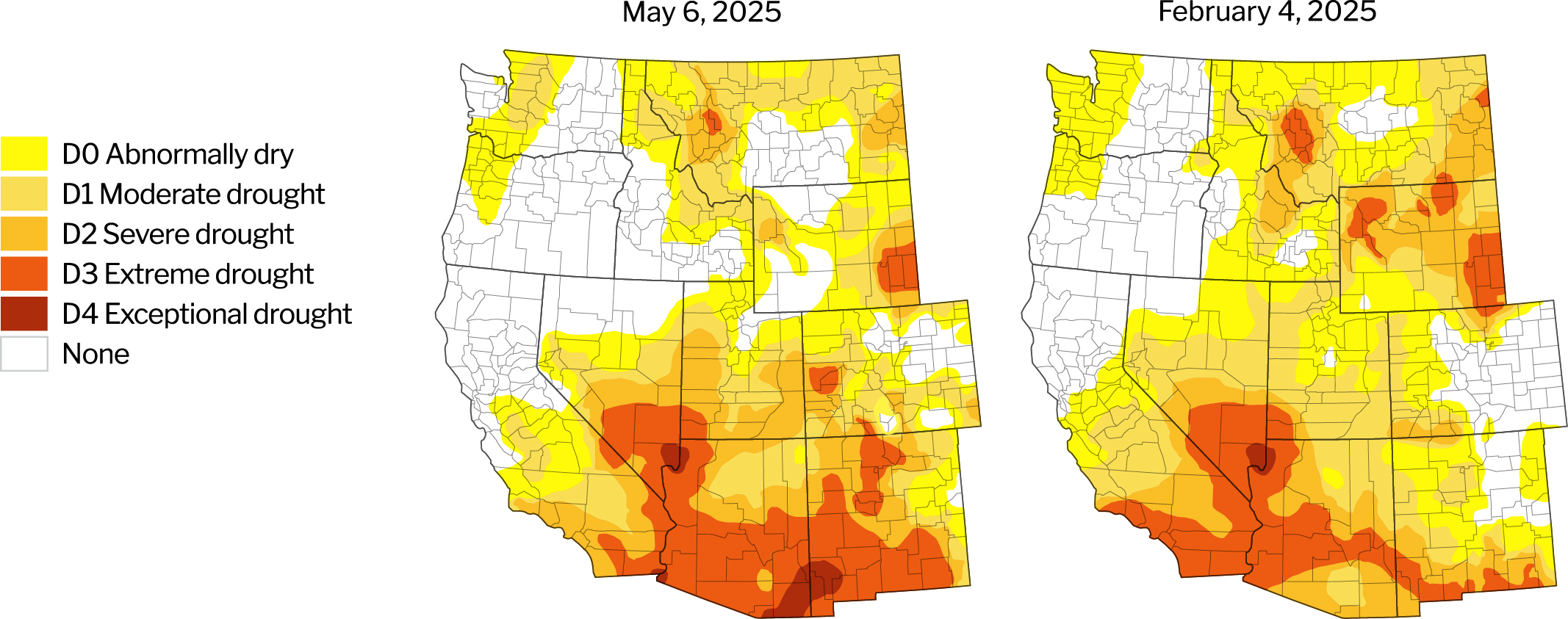
Source: U.S. Drought Monitor, University of Nebraska.
Description – The U.S. Drought Monitor provides a comprehensive look at drought conditions across the U.S., categorizing areas by intensity (no drought to exceptional drought). This tool helps agriculture producers understand water availability and make informed decisions about crop management.
Year-to-date precipitation
Year-to-date precipitation levels (Oct. 1 – May 7, 2025) are generally favorable throughout the West, with the exception of Arizona which continues to experience precipitation deficits. See the ‘Updates impacting water access’ below for state specific analysis on water conditions.
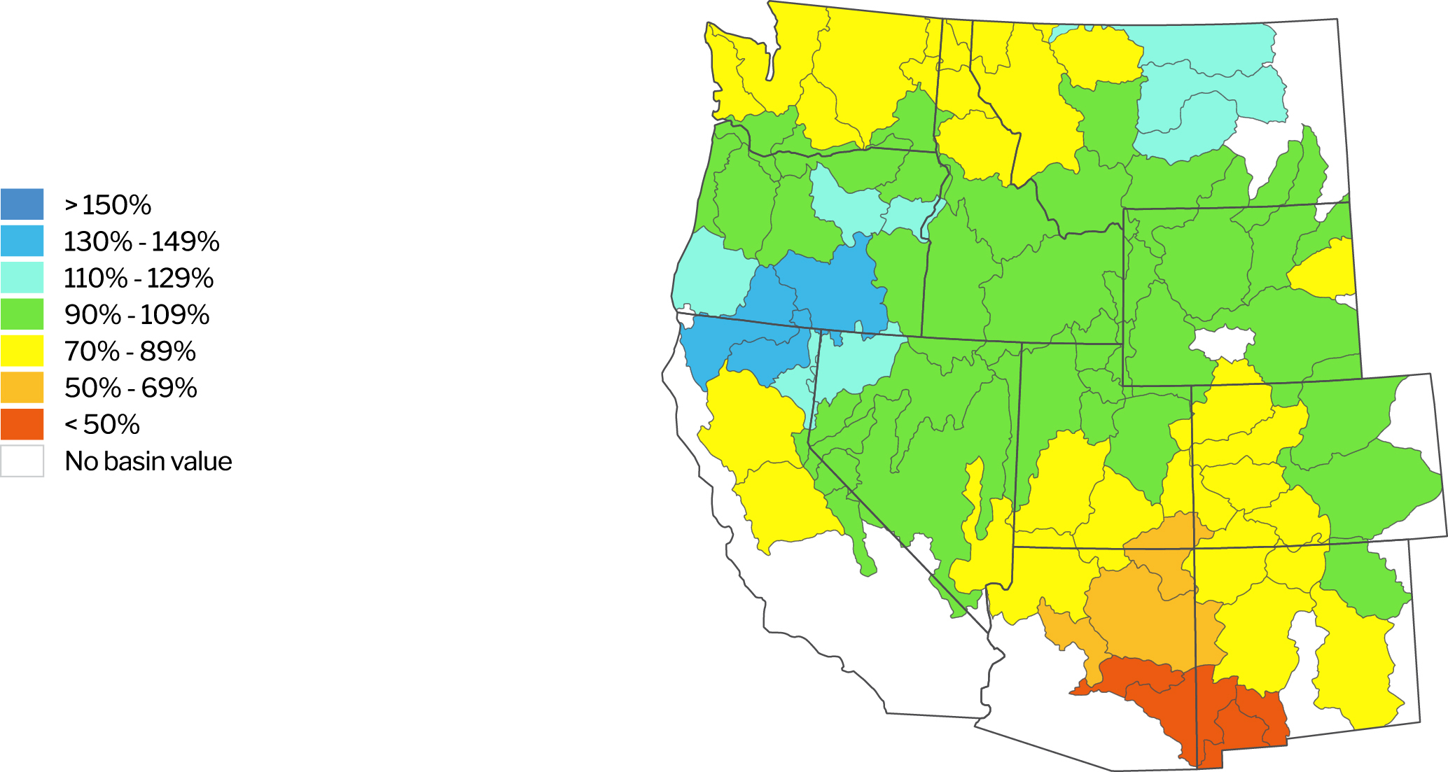
Source: Natural Resources Conservation Service. NWCC Interactive Map. Data as of May 7, 2025.
Description – The NWCC Year-to-date Precipitation Map provides a detailed overview of precipitation levels across the U.S., comparing current data to a historical average. Similar to the Drought Monitor, this tool helps agriculture producers understand water availability and make informed decisions about crop management.
Reservoirs with low water levels
California reservoirs continue at strong levels. Over the last quarter, Four Mile Lake in Oregon as well as Bumping and Rimrock Reservoirs in Washington improved notably and now have water levels above 80% of average. In contrast, water levels in Reservoir A in Idaho and Cold Springs in Oregon fell and were added to the list below.
Reservoirs with water levels below 80% of their historical average
| Location/Region | Reservoir | Percent of average level | Percent of previous year |
|---|---|---|---|
| Colorado River Basin | Lake Powell | 54% | 97% |
| Lake Mead | 53% | 91% | |
| Deschutes River Basin, OR | Crescent Lake | 44% | 147% |
| Lewiston Orchards | Reservoir A | 75% | 66% |
| Umatilla | Cold Springs | 70% | 96% |
| Yakima River Basin, WA | Cle Elum | 74% | 105% |
| Kachess | 67% | 118% | |
| Keechelus | 74% | 112% |
Data as of May 8, 2025.
Source: Bureau of Reclamation: Reservoir Storage. California Department of Water Resources. Arizona Department of Water Resources.
Description – Reservoirs are an important source of water for agriculture producers throughout the West. This section identifies those with water levels at 80% or below of their historical average for the given period. Reservoirs at or above 80% of their historical average water levels are not included in this list.
Updates impacting water access
United States
The Environmental Protection Agency (EPA) announced plans to revise the definition of Waters of the United States (WOTUS) to align with a recent Supreme Court ruling that narrowed the Clean Water Act’s authority. WOTUS defines the scope of federal jurisdiction of water bodies and by extension, sets limits on how closely producers can apply fertilizers and pesticides along streams, rivers and other bodies of water.
The Interior Department issued a funding freeze to activities under the Inflation Reduction Act, many of which included water conservation efforts and infrastructure projects across the West. While funds have been released in some cases, the vast majority remain inaccessible.
Efforts to update the Columbia River Treaty between the U.S. and Canada was paused amid the Trump Administration’s review of international agreements. The treaty was established 64 years ago and governs use of the Columbia River Basin for flood control and hydropower generation. A tentative agreement was reached last year following six years of negotiation. The pause is unlikely to impact agriculture producers directly, but may have implications for power generation and flood control.
Arizona
The Colorado River will be managed under a Lower Basin Tier 1 shortage classification, which will decrease Arizona’s entitlement by 512,000 acre-ft as well as reduce 74,030 acre-ft of water to the Central Ariona Project (CAP) Non-Indian Agricultural (NIP) pool. March storms helped to bring much-needed moisture to north central Arizona, though water year precipitation remains much below average for most of the state.
The Interior Department’s funding freeze halted progress on the Lower Colorado River System Conservation and Efficiency Program (LC Conservation Program). The LC Conservation Program allocated $4 billion to support fallowing incentive programs and infrastructure improvements. The decision to not fund has increased uncertainty and concern among irrigation districts already pressured by severe drought conditions.
The Colorado River Compact, an agreement that manages water allocations to lower basin states (Arizona, California and Nevada) and upper basin states (Colorado, New Mexico, Utah and Wyoming), expires in 2026. Negotiations among these states are contentious and show little progress towards resolution. Lower basin states want the upper basin to take a greater share of future cuts, and Arizona wants other states to help ensure that CAP water continues flowing.
California
Strong snowpack levels will support reservoir levels in 2025. There is a moderate level of flood risk as snowmelt exceeds accumulation capacity.
The United States Bureau of Reclamation (USBR) increased the Central Valley Project allocation for all South-of-Delta irrigation contractors from 40% to 50% of contracted supply and is anticipating a full allocation from Upper Klamath Lake to support the Klamath Project (impacting water access for producers in north central California). All other Central Valley Project allocations, including those for North-of-Delta and Friant irrigation contractors, are unchanged. The California Department of Water Resources (DWR) announced in the State Water Project an increase in allocation from 40% to 50% of contracted supply. California’s snowpack peaked at 100% of average on April 4, and snowmelt is just beginning to flow into major supply reservoirs, which have begun releasing water in anticipation of more runoff and to satisfy ecological maintenance requirements in major rivers and the Delta.
Paso Robles City Council opted into a Joint Powers Authority (JPA) with the city of Paso, San Luis Obispo County and the Shandon-San Juan and Estrella-El Pomar-Creston Water Districts to address water overdraft (where withdrawals exceed recharge). The JPA allows the participating agencies to fund regulatory and administrative functions under the Sustainable Groundwater Management Act and administer overuse fees. San Miguel Community Services District elected to not join the JPA.
The State Water Resources Control Board (SWRCB) voted to grant Kern County groundwater sustainability agencies additional time to refine a coordinated Groundwater Sustainability Plan (GSP) before considering placing the subbasin under probation at a hearing continued until September 17. The SWRCB acknowledges that Kern’s groundwater regulators have made significant progress toward coordination and addressing deficiencies in their GSP, although some concerns remain. Groundwater Sustainability Agencies (GSA) have until June 20 to issue their revised plan, which will be reviewed by the Board prior to the hearing in September.
The Porterville Irrigation District board voted to abandon a partnership with the City of Porterville to manage area groundwater, and a public hearing on whether to form its own groundwater agency was set for May 13. The point of contention centered on the makeup of the board and concerns around transparency/accountability laws. The district says forming their own GSA would preserve their autonomy in setting groundwater policy, while the district’s growers voiced concerns about inadequate representation if the existing district board governs the new GSA as well.
DWR approved GSPs governing 15 subbasins across the state. These subbasins are primarily located in the Sacramento Valley, the far north of California and the Central Coast.
The Trump Administration announced the release of $315.5 million for state water storage projects, of which $200 million is allocated to Sites Reservoir in California. These funds were initially allocated under the Inflation Adjustment Act.
Idaho
Snowpack levels range from 70% to 97% of average across much of Idaho; however, the Upper Snake basin is at 67% and falling quickly. While water reservoir storage is generally favorable and should support irrigated production this season, below average precipitation and snowpack levels may result in less water carryover for the next year or so.
Oregon
Oregon is largely out of drought and snowpack throughout much of the state is above average, particularly in the southern Oregon Cascade Range, Steens Mountain and Blue Mountain Range in eastern Oregon. Rapid snowmelt risks leading to flood conditions in Southern Oregon.
Oregon has allowed the Port of Morrow to violate its water pollution permit by spreading nitrogen-contaminated wastewater on nearby agricultural fields. The port is concerned that a wet winter will stress its storage capacity in the spring and limit its ability to process wastewater from businesses.
The Bureau of Reclamation is anticipating a full allocation from Upper Klamath Lake to support the Klamath Project, which should support water access for producers in south central Oregon.
Montana
Late winter and early spring brought moisture throughout Montana, but soil moisture could dry out quickly without additional precipitation this spring. Northeastern Montana remains very dry, while snowpack levels range from 80% – 90% of average in the Northern Rockies. Anecdotal reports suggest snowpack levels in the Big Horn Mountains in Wyoming are slightly below average. These mountains source many of the rivers in eastern Montana.
Anecdotal reports indicate that the Greenfields Irrigation District in northcentral Montana, which depends on the Sun River drainage(s) for water, will have a water shortage again this year with irrigators likely to receive 12 inches. Pondera County Canal and Reservoir Company in northcentral Montana, which depends primarily on the Birch Creek drainage(s) for water, will get 4 inches of irrigation again this year. Conditions in the Camas/Hot Springs area in northwestern Montana, which depends on water from Little Bitterroot Lake by the community of Marion, are challenging as the lake is reportedly extremely low.
Progress continues in repairing the St. Mary siphon in Glacier County, which suffered a catastrophic failure in June 2024, and current estimates suggest completion by July 2025. The siphon is part of the Milk River Irrigation Project in north-central Montana and diverts water from the St. Mary River to the North Fork of the Milk River. The Milk River is essential for irrigation and potable water for Hi-Line communities and may currently be at historically low levels. The Fresno Reservoir is reportedly at relatively low levels and releases are tentatively scheduled for May 20. A tentative allotment of a half acre-foot per acre has been proposed for this year.
Washington
Snowpack conditions are notably below average for much of the state, including the Upper Columbia Basin (62% of normal), Puget Sound Basin (63%), Middle Columbia Basin (77%) and Lower Columbia Basin (88%). Rapid snowmelt was reported for the northern Cascades in late March and this may reduce the length of peak river flows during the summer. The state extended emergency conditions in the Yakima Basin and while senior water rights holders can expect 100% of their allocations, junior water rights holders are predicted to receive only 58%.
The Odessa Groundwater Replacement Program, designed to replace groundwater use from the Odessa Subarea Aquifer with Columbia River surface water, has begun to deliver water on a recently completed irrigation system. This system is expected to conserve over 16,000 acre-feet of water use annually from Odessa Subarea Aquifer.
Return to Industry Insights home page
IN THIS SECTION
![]()
.jpg?Status=Master&sfvrsn=68087301_1 "My project-1 (26)")
Economic headlines, data and trends
Monthly economic trends, data and major industry headlines.
Learn more